Walks in Lochalsh - a work in progress
Also see THE DIRTY 30 - an amazing circuit trek over 30 miles of Lochalsh
Stay safe in the mountains and wilderness - read the basic safety information here Also helpful tips and tricks on what to take with you. Rescue contact numbers etc.

Walks for all abilities in Lochalsh
As Lochalsh (and the Isle of Skye) is a vast rural landscape it follows that there are literaly hundreds of great walks in the area. Over the years we will be adding to this section to form (hopefully) a comprehensive guide to walking in Skye and Lochalsh.
Walking is one of the best ways to get to know a place and appreciate the surroundings, it also costs nothing and is beneficial for your health! Lochalsh offers many different walking opprtunities whether it is on one of the National Trust signposted (colour coded) trails out of Balmacara or a stroll along the seafront from Balmacara to Glaick or along a forestry track in the woods near Achmore.
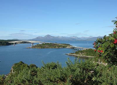
"Walking the bridge" is a good place to get started - the bridge to Skye at Kyle of Lochalsh. There is a cycle/pedestrian path adjacent to the trunk road and it offers a safe (if at times breezy) way of "walking" the sea to Skye. The two bridges have panoramic views in each direction and give you an idea of the attraction that Eilean Ban had for Gavin Maxwell (you can look down on the whitewashed cottage as you walk past). If you are lucky you might see an otter or two playing by the shore.
The walks vary from easy ( rambling on lanes / tarmac etc) to long or difficult i.e. scrambling through heather up mountains. We will try to give an indication with each listing. Please please please do not go into the hills unprepared (warm clothes, water (for Cuillin ridge etc) and map/compass. Torch and mobile phones are useful too. Also tell someone RESPONSIBLE where you are intending to go and when you expect to reach your destination. Each year Mountain Rescue are called out because people think they know better and dont use this simple advice!
Please also note that the walks below are NOT GUIDES. They are suggestions only and you should ALWAYS use an ordnance survey map and NOT rely in any way on our instructions.

The Skye Bridge
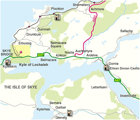
Walks in and around Kyle of Lochalsh
Balmacara to Auchtertyre Hill (signposted - loop or one way) GridRef: NG807280
On the road going TO Reraig from Balmacara Square, it is possible to park your car on the Left hand side of the road (opposite Cromarty House) and walk up the Forestry road towards Sgurr Mor. The logging road is very easy to walk/mountain bike and takes you up to the waterfall of Balmacara Burn (a couple of NT footpaths lead off from this road, either going to Reraig or to Coille Mor). If you keep going on the road it loops round to Coille Mor and you can complete the circuit by walking back DOWN the Plockton road to where you parked your car.
The slopes leading off from the logging road are precariously steep in a couple of places so keep an eye on small children. Otherwise it is a safe and enjoyable walk. NOTE The logging track is relatively new and may not be complete on some maps. LM
Balmacara to Kyle (signposted - one way) GridRef: NG800280
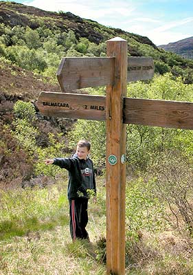
A really easy one .. Join the path OPPOSITE the entrance to the National Trust Woodland Walks. Be careful its a busy road and you have to cross over to the Balmacara side of the road if you parked at the Woodland Walk. The path is easy to follow and there are spectacular views most of the way. Its only a few kilometers but well worth the walk. Uphill and half way (or more) you will pass the sign in the picture at the top of this page. There is a burn of cooling water here. Shortly thereafter going down the slope and through the trees there is a fascinating ant colony. The final stretch of the walk opens up a vista to reveal the Skye Bridge and all of Skye. Ed
Kyle Loch Scalpaidh Kyle round route (not signed - dangerous) GridRef:NG780280
Head out of Kyle, direction Inverness A87 and go up the hill round the bend and down again. At the bottom of the hill on the left is a lay-by. The signpost points ip a steep hill to Loch Scalpaidh. Up through the birch trees on your left and right are the remains of neolithic settlements although you will need a keen eye to see them. Out of the trees and still climbing up the path becomes precipitous and care is required lest a tumble ensue. Further still and the woods (birch thickets) appear on the right and the path starts to level out - phew! If by this time you are still on the right trail you will come to the signpost pictured at the top of the page. Carry STRAIGHT on to Loch Scapaidh. (The right direction goes to Balmacara and the left back to Kyle of Lochalsh should you want to cut short your walk.) Over the stile Here the ground can become moist or boggy and its best to try looking ahead to see where the path goes as it tends to peter out in places. Hopefully you will have passed fire beating equipemnt and crossed the burn by now and be heading up to the loch. When you get there, keep to the RIGHT side of the loch - its by far the easier route. At the far end note the leeches and little fish in the burn, this suggests bigger fish in the loch and the resident heron might agree. Skirting the head of the loch you should be able to pick up the track, although again its difficult to follow in places. If however you keep going by the map, you will intersect with the road in ten minutes or so. Turn left and head down the road for a mile or so until you meet the main road again turn left direction Kyle and be mindful of the traffic, especially at the top of the first hill at the back of Tingle Creek Hotel, (named after the racehorse of the same name). Just follow the road for a few miles into Kyle, there is plenty to see on the way back. Ed

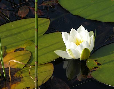
Water Lilly above Balmacara
Kyle Old Golf Course Plock of Kyle (not signposted) GridRef: NG755275
Start from the swimming pool in Kyle and proceed up Plock Road - uphill the entire way. At the top of the road continue up the hill past the houses where the surfaced road continues... until a fork in the road is encountered. Turn left and keep on up the hill widing round until on your right you see a tiny path. Here you could if you wanted continue up to the top of the hill where the flagpole is and take in the view of the Skye Bridge. On the way back follow the little path down through the heather. Spectacular panoramas of the Applecross Hills, Isle of Raasay and the Cuillin Hills on the Isle of Skye are all around you. Follow the path until you see the car park for the old golf course through the trees and where the paths meet turn LEFT to the car park. Here you can either head back UP the hill back to the village of Kyle or better still, go down on to the old golf course. Hopefully its impossible to get lost here - just remember the way back. You should see otters, deer, rarer species of moths and birds. Graylags, Herons, Whimbrel and Oystercatchers are usually here in season. The meadow flowers in spring are just sublime. This area called the Plock Of Kyle was gifted to the poeple of Kyle and cannot be used for development. Ed
Duirinish to Achnahinich (not signposted but easy to follow) GridRef: NG820320
Start at the Achnandarach junction (there is a couple of parking spaces) and follow the road past the hamlet of Achnandarach up through the trees till you come to the Loch Achnahinich. Here is a great place to spot dragonflies and pike in the summer. Its also a great place for a picnic. Walk along the lochside until you come to a fork in the road and take the left road through the gate and up through the trees. Climb steeply up the path to the top of the hill where you get to a gate and back into the open. Follow the road down till you get to another fork. If you are wanting a short walk carry straight on. If not you can turn right here and follow the path down and then up the hill to the radio mast. Its steep, but well worth the effort once you get to the summit. I went to wedding up here and it truly is an open cathedral! This is Bealach Mor and the views here are spectacular. Wildlife here is also interesting and its likely you will encounter rarer species - just take your time and keep your eyes open. Continue back down the way you came and re-join the path. Heading down the track becomes wooded again and when you get to where the path joins the road turn left. Follow the road (watching for cars) till you get back to Achnandarach. Ed
Linear Plockton station to Kyle of Lochalsh (10 miles, 4 hours), returning by train.
Leave Plockton just below station (opposite high school) on road to village by signposted path
towards Duncraig (follows wooded shoreline and railway). After the path
goes under the railway and turns up a hill there is a path junction:
take the "Creagdaroch" signposted route straight on (rather than the
left turn to Duncraig).
This reaches the road at GR 808327. Turn right, but almost immediately
bending left at road junction to GR 810325. Here, turn left along
forest track all the way round through Creagdaroch Woods to reach Loch
Achnahinich. At GR 808310, leave the Loch side by the "Balmacara"
signposted path. The path is followed initially beside the Loch, then
over the pass and down to Balmacara Square.
From the Square, take the Kyle road until just before its junction
with the A87. At this point, GR 802279 (near the National Trust Woodland
Walks) join the signposted path on the right to Kyle of Lochalsh. The
path is high above the A87 all the way and affords excellent views over
Loch Alsh.
Optional extension: continue on over the bridge to Kyleakin (2.5 miles,
50 minutes), returning to Kyle by bus.
Our thanks to Mr D Joanes - Berwick-upon-Tweed
Walk along River Carron to Strathcarron
Walk from Morvich up Glen Licht
Walk to the broch at Totaig (Casteal Grugaig)
Walk to Leiter Fura through Kinloch Forest (Isle of Skye, Sleat)
If you have any information about WALKS IN AND AROUND SKYE AND LOCHALSH please send it in an email to : sales@lochalsh.com and we will update this section of the website accordingly.

